How the name "Fasli" appeared
Fasli was prior to the Turkish invasion of 1974 a Turkish Cypriot village (Φάσλι in Greek, Faslı in Turkish). Prio Cyprus Centre gives an explanation1http://www.prio-cyprus-displacement.net/default.asp?id=490 why the village was named as such, indirectly implying that it was founded by Muslims: "It is believed by many that the name Phasli or Fasli derives from fasla, meaning “plot of land.” The villagers of Androlikou and Fasli believe that after a land dispute in Androlikou, the agha of the village told one of the opponents that he was willing to give him one fasla if he agreed to move where the current village is situated. He apparently accepted the offer, and the village was founded and called Fasla. The Turkish Cypriots eventually slightly changed the name from Fasla to Faslı". But this onomatology of Prio Cyprus Centre is problematic, simply because there is no such "fasla" word in the Turkish dictionary that relates to land. Now, in the case that the word is older than the Turkish language, a good source to check is the Ottoman dictionary. In this case, according to the Ottoman Turkish English dictionary2https://osmani.ahya.net/english-turkish-dictionary-40064.html, "fasla" is "a date-palm sucker planted out". But this word has obviously nothing to do with "land" as previously stated.
An older source from Prio Cyprus Centre is Nearchos Klerides3The Turkish Cypriot representative of Prio Cyprus Centre seems to be totally unaware of the existence of Klerides or ignoring his work , who published his book "Villages and States of Cyprus" in 19614Νέαρχος Κληρίδης - Χωριά και Πολιτείες της Κύπρου, Λευκωσία 1961.. According to Klerides, "the name of this small settlement is of the very corrupted names of Cypriot villages because the initial name was Phaselis [Φάσηλις], and it was named as such by its first inhabitants of the area who had arrived from Phaseli of Lydia5Lydia was a huge Kingdom in western Asia Minor 1200-546 BC". Klerides makes a geographical mistake here, as he clearly meant to say the ancient Greek city of Phaselis of Lycia6He confused Lydia for Lycia (today Antalya province), which was founded in 700 BC and had commercial ties with Cyprus (it was located extremely close to the Akamas peninsula, where Fasli is today located).
Was Fasli initially a Greek founded village?
But is Fasli an Ottoman founded village? According to Terrabook7https://cyprus.terrabook.com/cyprus/page/fasli/, in the village, someone "can see the ruins of the church of St. Karios" [Άγιος Κάρυος]. If that is a fact, the village's initial inhabitants should have been Christians converted to Islam due to taxation, as Christians paid heavily on taxation to the Ottomans. Hence, the name of the village should have prior to that been other, and Prio Cyprus Centre's story about the birth of the name of the village could potentially turn out to be a myth.
Terrabook's statement that there was a church dedicated to Saint Karios is somehow problematic. In our days, we most likely have no surviving knowledge about a saint called "Karios", but this does not mean the statement is false as many local saints appeared throughout the centuries of whom their names have passed in oblivion. Indeed, on the page UKblow8https://ukblow.info/chart/o-agios-matsoukares-sten-tsada-tes-paphou-ereipia/mJ6jk5azoKzVhpc.html there is a statement that, among other saints in question, Saint Karyos was honoured in Fasli. Τo whomever the church was dedicated to is not important, as long as that church existed and its remains are out there somewhere, still available to be seen.
Toponyms reveal a Greek place
The Cyprus Permanent Committee for the Standardization of Geographical Names (CPCSGN) was officially established by the decision of the Council of Ministers no. 15.769 of 21.4. 1979 and constitutes the only competent National Authority for the Standardization of Geographical Names in Cyprus. According to this Committee, in Fasli is recorded an ancient monument of Agia Trooditissa [Saint Trooditissa]9https://www.geonoma.gov.cy/myfiles/ekdoseis/cygazetteer/29/#zoom=z, and the following streams that are in the Greek Cypriot dialect: "Argaki tis Katouristras [Stream of the place that pees water]"10https://www.geonoma.gov.cy/myfiles/ekdoseis/cygazetteer/140/#zoom=z, "Argaki tis Mavroschinias [Black schinus's stream]"11https://www.geonoma.gov.cy/myfiles/ekdoseis/cygazetteer/142/#zoom=z, "Argaki tis Pernias [Quercus's stream]"12https://www.geonoma.gov.cy/myfiles/ekdoseis/cygazetteer/143/#zoom=z, "Argaki tis Petreris [Stream of the rocky (area)]"13https://www.geonoma.gov.cy/myfiles/ekdoseis/cygazetteer/144/#zoom=z, "Argaki ton Kataklystron"14https://www.geonoma.gov.cy/myfiles/ekdoseis/cygazetteer/166/#zoom=z, "Argaki ton Kontomersinon [Stream of the short myrtuses]"15https://www.geonoma.gov.cy/myfiles/ekdoseis/cygazetteer/167/#zoom=z, "Argaki ton Petron Pou Chaloun [Ruining stones' stream]"16https://www.geonoma.gov.cy/myfiles/ekdoseis/cygazetteer/169/#zoom=z, "Argakia tou Sarantari [Streams of the 40 year old]"17https://www.geonoma.gov.cy/myfiles/ekdoseis/cygazetteer/172/#zoom=z. There are also the following toponyms that are in the Greek Cypriot dialect: Vlampouros18https://www.geonoma.gov.cy/myfiles/ekdoseis/cygazetteer/242/#zoom=z, Koiladia [Plains]19https://www.geonoma.gov.cy/myfiles/ekdoseis/cygazetteer/559/#zoom=z, Kokkinokampos [Red plain]20https://www.geonoma.gov.cy/myfiles/ekdoseis/cygazetteer/578/#zoom=z, Kourvellos 21https://www.geonoma.gov.cy/myfiles/ekdoseis/cygazetteer/629/#zoom=z, Mesolaona [Fields in the middle]22https://www.geonoma.gov.cy/myfiles/ekdoseis/cygazetteer/842/#zoom=z, Xiourides23https://www.geonoma.gov.cy/myfiles/ekdoseis/cygazetteer/913/#zoom=z, Palialona [Old fields]24https://www.geonoma.gov.cy/myfiles/ekdoseis/cygazetteer/928/#zoom=z, Pernia [Quercus tree]25https://www.geonoma.gov.cy/myfiles/ekdoseis/cygazetteer/996/#zoom=z, Petreri [Rocky]26https://www.geonoma.gov.cy/myfiles/ekdoseis/cygazetteer/1004/#zoom=z, Petrovouni [Rocky small Mountain]27https://www.geonoma.gov.cy/myfiles/ekdoseis/cygazetteer/1006/#zoom=z, Pikrathashia [Bitter almond tree]28https://www.geonoma.gov.cy/myfiles/ekdoseis/cygazetteer/1020/#zoom=z, Sykia [Fig tree]29https://www.geonoma.gov.cy/myfiles/ekdoseis/cygazetteer/1164/#zoom=z, Toumpekkia30https://www.geonoma.gov.cy/myfiles/ekdoseis/cygazetteer/1196/#zoom=z, and Cheroullas31https://www.geonoma.gov.cy/myfiles/ekdoseis/cygazetteer/1266/#zoom=z. We also know about a hill called "Kapsalomoutti [Burnt Hill]"32https://www.geonoma.gov.cy/myfiles/ekdoseis/cygazetteer/528/#zoom=z.
There are also toponyms for Fasli found in the Turkish language, proving that the information given by the Committee is not biased, such as Boklu Tepe33https://www.geonoma.gov.cy/myfiles/ekdoseis/cygazetteer/242/#zoom=z, Kkiampiria34https://www.geonoma.gov.cy/myfiles/ekdoseis/cygazetteer/545/#zoom=z, Koca Tarla35https://www.geonoma.gov.cy/myfiles/ekdoseis/cygazetteer/554/#zoom=z, Muezzin Tarlasi36https://www.geonoma.gov.cy/myfiles/ekdoseis/cygazetteer/896/#zoom=z, and Tilki Teli37https://www.geonoma.gov.cy/myfiles/ekdoseis/cygazetteer/1190/#zoom=z. Interesting is also the toponym in the Cypriot dialect of "Mantra tou Gerotourkou" 38https://www.geonoma.gov.cy/myfiles/ekdoseis/cygazetteer/789/#zoom=z [Corral of the Old Turk]. Most likely the toponyms in the Turkish language prevailed on earlier in the local dialect, but all the rest survived as such through the centuries.
The abandonment of the village
According to Prio Cyprus Centre39http://www.prio-cyprus-displacement.net/default.asp?id=490, "No one was displaced from Fasli during the emergency years of the 1950s. However, in February 1964, during the period of intercommunal strife, all of Fasli’s inhabitants fled the village and sought refuge in nearby Androlikou, remaining there until the island’s division. During the 1974 war, most of the men of fighting age were arrested and sent to the Geroskipou POW camp, where in October 1974 they were exchanged with Greek Cypriot POWs from the north. During this same period, some Fasli Turkish Cypriots fled secretly over the mountains to the Turkish-controlled north. On 22 August 1975, UNFICYP evacuated the remaining Fasli Turkish Cypriots, along with the entirety (apart from a couple) of Androlikou village, to the northern part of the divide. They were mainly resettled in Myrtou/Çamlıbel, a village in the Kyrenia district of north Cyprus. Some also were resettled in Lapithos/Lapta, Famagusta and Morphou/Güzelyurt municipalities. The number of Turkish Cypriots from Fasli who were displaced after 1974 was around 80-90".
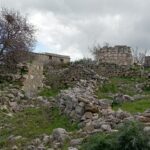
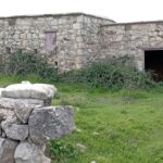
Architecture
The houses of Fasli in the early 20th century were entirely stone-built, and their roofs were flat, topped with clay for insulation purposes.
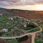
Fasli – November 2018
Fasli – February 2022

Special thanks to Sakis Vasiliou who granted me the re-publishing permission for the picture "Drone view".